find the very latest comprehensive news of the Nepal flood and summarize
A massive disaster struck northern and central Nepal on August 26, 2026, when a high-altitude glacial collapse near the Nepal–Tibet border sent a catastrophic flow of ice, rock, mud, and water nearly 100 kilometers down the Trishuli and Bhotekoshi river basins.
Human Impact and Casualties
-
Death Toll and Missing: According to the National Disaster Risk Reduction and Management Authority (NDRRMA), confirmed deaths in Nepal stand at 1,356, with nearly 5,000 people (4,994) remaining missing. Over 40 deaths and hundreds missing have also been reported on the Chinese side of the border in Tibet.
Hindustan Times+ 1 -
Affected Population: Over 84,000 people have been directly affected across five major districts—Rasuwa, Nuwakot, Dhading, Gorkha, and Tanahun.
UNICEF Australia -
Vulnerable Groups: At least 32,000 children are among those affected. Disrupted water networks, temporary shelters, and damaged health posts have heightened risks of waterborne illnesses and malnutrition.
UNICEF Australia+ 1
Primary Causes & Scientific Findings
-
Glacial Avalanche: Satellite mapping by the USGS confirmed that millions of cubic meters of ice and rock dropped nearly 1,900 meters from a glacier high in Langtang National Park. The impact generated seismic energy equivalent to a magnitude 5.2 earthquake.
USGS+ 1 -
Role of Climate Change: Experts attribute the disaster to accelerating high-altitude temperature increases, rapid glacial retreat, and unstable glacial lakes across the Qinghai–Tibet Plateau.
Hindustan Times
Infrastructure Damage and Supply Line Disruption
-
Bridges and Roads: The surge destroyed 41 motorable bridges across northern corridors and severed critical ground links between Kathmandu, China, and district headquarters like Dhadingbesi.
-
Hydropower Loss: More than 12 hydropower projects along the river corridor suffered severe structural damage, with floodwaters inundating tunnel complexes.
Hindustan Times -
Rebuilding Costs: The Department of Roads estimates direct damage to transport networks at NPR 30 billion ($225M+), with long-term reconstruction expected to exceed NPR 50 billion.
Hindustan Times
Relief Efforts & Global Appeal
-
International Aid: China and India have supplied temporary Bailey bridges to reconnect critical border crossings and trade routes. Immediate humanitarian relief—including clean water kits, medical tents, and food—is being distributed by local authorities, UNICEF, and international partners.
Hindustan Times+ 1 -
Call for Climate Justice: The Nepali government announced a initial recovery plan estimated at $5 billion. Officials are pitching this request to international donors, the World Bank, and the UN on the grounds of climate justice, highlighting that low-emission developing nations bear the brunt of climate-driven disasters.
Hindustan Times
where else in the world could this occur?
High-altitude glacial collapses and devastating Glacial Lake Outburst Floods (GLOFs) are not unique to Nepal. Globally, over 15 million people live in downstream paths exposed to sudden glacial hazards, driven by warming temperatures, retreating glaciers, and unstable meltwater lakes.
The primary regions around the world facing similar catastrophic vulnerabilities include:
1. The Hindu Kush Himalaya (The “Third Pole”)
This region contains the highest global concentration of exposed communities, with over 9 million people at risk.
-
India (Sikkim, Uttarakhand, Himachal Pradesh): Extremely susceptible to cascading ice avalanches and GLOFs. Significant recent precedents include the 2013 Kedarnath disaster and the 2023 South Lhonak lake outburst in Sikkim, which destroyed major dams and downstream towns.
United Nations University+ 1 -
Pakistan (Gilgit-Baltistan and Khyber Pakhtunkhwa): Home to over 3,000 glacial lakes, with more than 30 identified as critically unstable. Frequent summer outburst floods regularly sever the Karakoram Highway and isolate remote valley populations.
-
Bhutan: High-altitude moraine-dammed lakes (such as Thorthormi Lake) threaten downstream valleys, critical hydropower infrastructure, and historical population centers like Punakha.
2. The South American Andes
The Andes represent the second most vulnerable mountain zone globally, where steep topography creates severe runout risks.
-
Peru (Cordillera Blanca): Geologically one of the most hazardous zones in the world for ice-rock avalanches triggering lake breaches. Historic events in Laguna Palcacocha and the Huascarán mountain collapses devastated towns like Yungay and Huaraz, causing tens of thousands of casualties.
-
Bolivia & Chile (Patagonia): Glacial lakes in Northern and Southern Patagonia—such as Lago Cachet Dos—frequently experience outburst events, discharging millions of cubic meters of water into pristine river systems.
Antarctic Glaciers
3. North America
-
Alaska & the Pacific Northwest (USA & Canada): Rapidly retreating glaciers form dynamic ice-dammed and moraine-dammed lakes. Southeastern Alaska (e.g., Suicide Basin near Juneau) experiences recurrent outburst flooding, impacting municipal infrastructure, airstrips, and homes.
Wikipedia+ 1 -
Pacific Cordillera (British Columbia): Steep glacial valleys face risks of structural moraine collapse triggered by warming permafrost and heavy rainfall events.
4. Central Asia (Tien Shan and Pamir Mountains)
-
Tajikistan, Kyrgyzstan, and Kazakhstan: Thousands of high-altitude glacial lakes sit above densely populated agricultural basins, including the Fergana Valley. Rising summer temperatures accelerate ice melt and slope instability, posing cross-border flood threats.
5. European Alps
-
Switzerland, France, and Italy: While early-warning and engineering controls are advanced, warming permafrost destabilizes high-peak rock faces and hanging glaciers. Outburst events from subglacial pockets and unstable glacial margins remain a constant threat to Alpine villages, tourism corridors, and hydroelectric systems.
write this in Spirit Daily style: Alaska & the Pacific Northwest (USA & Canada): Rapidly retreating glaciers form dynamic ice-dammed and moraine-dammed lakes. Southeastern Alaska (e.g., Suicide Basin near Juneau) experiences recurrent outburst flooding, impacting municipal infrastructure, airstrips, and homes.
Pacific Cordillera (British Columbia): Steep glacial valleys face risks of structural moraine collapse triggered by warming permafrost and heavy rainfall events.
Across the Pacific Northwest and into the rugged wild of Alaska, nature is stirring in dramatic fashion. Unstable glacial lakes are swelling as melting ice rapidly recedes, giving birth to volatile ice-dammed and moraine-bound basins that threaten sudden, devastating outburst floods. Downstream, coastal communities face a constant peril: in places like Suicide Basin near Juneau, torrents of water periodically burst forth without warning, ripping through municipal infrastructure, washing out airstrips, and encroaching on quiet residential homes.
Farther south along the Pacific Cordillera in British Columbia, towering peaks and steep glacial valleys tell a similar story. As permafrost deepens its thaw and unusual torrential rainstorms lash the high country, fragile, centuries-old moraines face structural collapse, sending massive cascades of rock, mud, and meltwater roaring into the valleys below.
what is moraines
A moraine is an accumulation of unconsolidated debris—dirt, rock, gravel, and boulders—that has been scraped up, carried, and deposited by a glacier as it moves across the land.
As a massive sheet of ice advances, it acts like a giant bulldozer, grinding down bedrock and collecting debris along its edges and underside. When the ice eventually melts or retreats, it leaves these mounds and ridges of loose sediment behind.
Primary Types of Moraines
-
Terminal Moraine: A ridge of debris pushed to the very furthest point reached by the snout or front edge of a advancing glacier.
-
Lateral Moraine: Parallel ridges of debris deposited along the sides or flanks of a glacier.
-
Medial Moraine: A ridge of debris running down the middle of a glacier, formed when two tributary glaciers merge and their lateral moraines combine.
-
Ground Moraine: An unsorted layer of till left behind on the valley floor under the main body of a melting glacier, forming gently rolling landforms.
Why Moraines Are Significant
In modern high-mountain environments, terminal and lateral moraines often act as natural, earthen dams that hold back melting glacial ice, creating high-altitude glacial lakes. Because these dams consist of loose, uncompacted rock and soil rather than solid bedrock, they are structurally fragile. Heavy rainfall, ice falls, or earthquakes can cause a moraine wall to fail, releasing millions of cubic meters of water in a sudden, catastrophic Glacial Lake Outburst Flood (GLOF).
find photos of Farther south along the Pacific Cordillera in British Columbia, towering peaks and steep glacial valleys tell a similar story.
Here are views capturing the sharp peaks, steep glacial valleys, and ice fields throughout the Pacific Cordillera range in British Columbia:
find most dramatic photo of Nepal flood and torrent
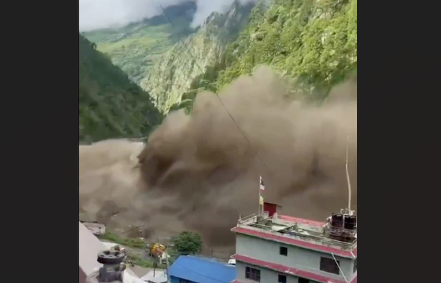
The following image captures the scale of the destruction along the river path in Nepal, showing entire structures inundated and buried by thick glacial silt, debris, and mud following the outburst flood:
what sacred place was near Nepal disaster
The primary sacred location directly associated with the site of the disaster is Gosaikunda Lake (and its surrounding high-altitude alpine lakes).
Located high in Langtang National Park at 4,380 meters (14,370 feet), Gosaikunda sits on the mountain slopes above the Langtang and Trishuli river corridors where the glacial collapse and flood disaster occurred.
Spiritual Significance
-
Hindu Tradition: Gosaikunda is revered as the earthly home of Lord Shiva. According to Hindu mythology, Shiva created the lake by driving his holy trident (trishula) into the mountain to draw cool water after drinking the poison that threatened to destroy the world. The resulting outflow formed the Trishuli River below.
Breeze Adventure+ 1 -
Buddhist Tradition: Tibetan Buddhists also hold the lake sacred, honoring it as a holy alpine water source with chortens and mani stones placed along its shores.
Travel Himalaya Nepal -
Ritual Connection to the Trishuli River: Religious tradition holds that Gosaikunda’s waters drain directly into the Trishuli River system. Every August, thousands of pilgrims travel up the Trishuli Valley to the lakes for the Janai Purnima festival, while those unable to make the high-altitude trek bathe in the Trishuli River below.
Breeze Adventure
Impact on the Sacred Corridor
While the high-altitude lake basin itself sits above the flood path, the Trishuli River valley corridor—the primary pilgrimage and access route leading to Gosaikunda and the Langtang region—was severely damaged. Ground access roads, bridges, and mountain trailheads passing through Dhunche and Syabrubesi were washed out, severing access to the surrounding holy sites, monasteries, and Tamang heritage trails.